Drive off the Oak Street Bridge heading north into Vancouver, and soon you'll be choosing which major road will carry you on in your travels: Oak, Granville, or even Cambie. But in Vancouver's early years, it was Hudson Street, to the east of Granville Street, that was a primary thoroughfare for commerce and transportation.
That's because Hudson Street--known at the turn of the 20th century as 4th Street--had one very desirable feature at its foot at the southern tip of what we now know as Marpole: A bridge over the North Arm of the Fraser River.
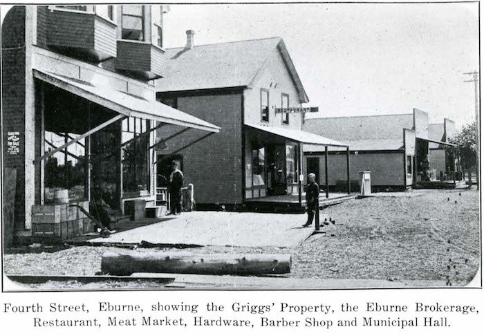 Eburne, now Marpole in Vancouver, in 1910. 4th Street is now Hudson Street (City of Richmond Archives, Photograph #1977 3 12)
Of course, we know the municipality on the south side of the crossing as Richmond, but it wasn't primarily called Richmond then. The larger piece of land we know as Richmond was called Lulu Island, and the smaller piece of land was Sea Island, and included a vibrant townsite called Eburne. That particular community once stood where the McArthurGlen mall is now. Sea Island and Lulu Island were joined by the Eburne Bridge (about where the Canada Line crossing is now).
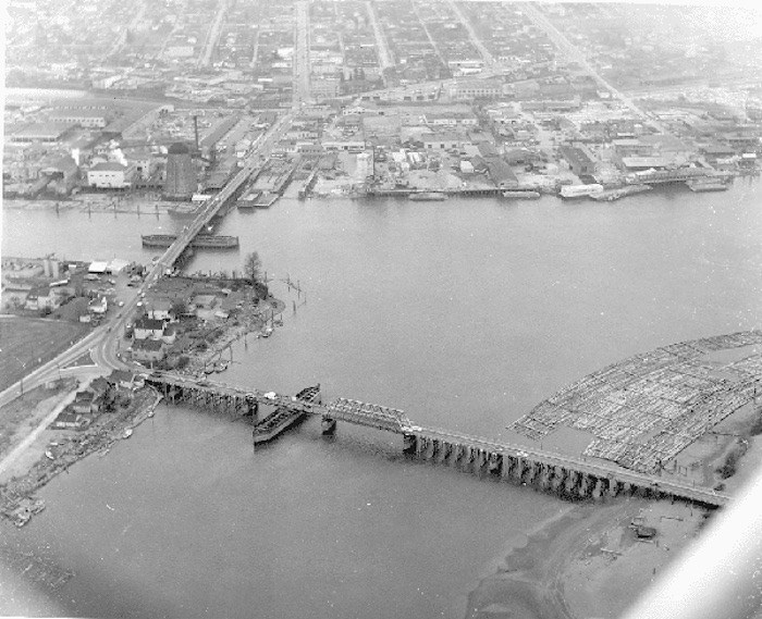 The bridge on the left is the Marople Bridge, joining Marpole in Vancouver with Sea Island. The Eburne bridge at right joins Sea Island to Lulu Island, which is Richmond. You can see the Eburne Sawmill just to the left of the northern point of the Marpole Bridge. This photo is from 1954; by 1957 the Oak Street Bridge was opened and the Marpole Bridge dismantled. The Arthur Laing Bridge follows the same span currently. (City of Richmond Archives, Photograph #1984 17 21)
On the north side, those crossing the bridge weren't going into Vancouver at the time; the southernmost part of the city as we know it now was at times considered Point Grey, and was briefly called Eburne, too. Named for settler William (Harry) Eburne, who started off on the Vancouver side before starting a community on the Richmond side, Eburne eventually became known as Marpole, which is the neighbourhood name to this day. Keeping up? It can definitely get confusing.
The Marpole Bridge was a low-level swing span crossing built in 1901 for vehicle and foot traffic; a rail bridge of the same name has been in place in the same area since about the same time. It was also used for the Vancouver-Steveston interurban streetcar line. That bridge was damaged in 1966, but replaced with one in 1967 that still stands today, and is owned by Canadian Pacific Railway.
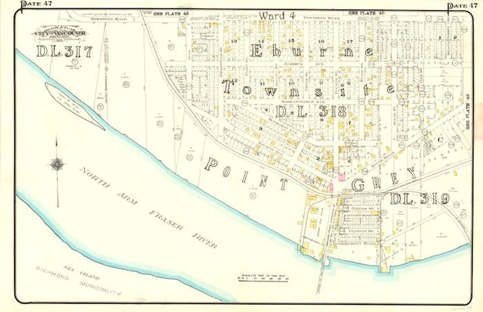
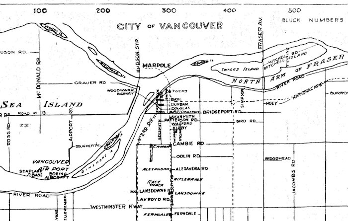 Section of a map of Richmond from the 1940s showing the North Arm of the Fraser River and Marpole in Vancouver (Map via City of Richmond Archives)
A swing span bridge meant it had to open and close to allow river traffic to pass through. It was also a highly popular crossing for vehicles in the 30s and 40s and into the 50s, particularly after the addition of the air terminal on Sea Island in 1931--yes, that's what became YVR (Vancouver International Airport). According to Chuck Davis' Vancouver history, the Marpole Bridge was raised over 7,000 times in 1954 alone.
 Eburne on the Vancouver side, then known as Point Grey. Later it would become Marpole. Mr. Eburne also gave his name to the first community on the south side of the Marpole Bridge, on Sea Island, now Richmond and the home of YVR airport (Photo: Vancouver Archives)
Marpole had enjoyed a tremendous boom in the first part of the 20th century, as the farmlands gave way to developments and when the sawmills began operating in the area. The Eburne Sawmill was located on the west side of Hudson Street at the base of the community right on the river. Hudson Street itself was a central road for businesses, serving as a corridor, though the streetcar used Oak Street.
But all that traffic and usage (not to mention the growing impracticality of operating a swing span bridge) meant that it was time to rethink the North Arm Crossing. The Oak Street Bridge was opened on July 1, 1957. The tolled crossing sent traffic to the east, and as a result, Hudson Street lost business, particularly when the Marpole Bridge was dismantled later that year.
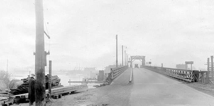 A vehicle heading south from Point Grey, Vancouver (now Marpole) to Sea Island, Richmond via the Marpole Bridge. The sign reads Fraser River North Arm. In the left on the horizon is the Eburne Bridge, connecting Sea Island’s Eburne community with Lulu Island, Richmond. (Photo: Vancouver Archives)
A bridge to Sea Island, called the Moray Bridge, was put in place to remove congestion from the new Oak Street Bridge (which shed its tolls in 1959), but by the early 1970s, the demand was too great. The Arthur Laing Bridge, connecting South Vancouver and the airport, was opened in the exact same spot as the Marpole Bridge, only much higher and minus the swing span.
The next time you're headed to YVR, imagine a hundred or more years back, when you could stroll across the Marpole Bridge to Eburne, over the North Arm between Marpole and Sea Island.
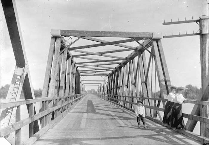 My great-grand Aunt, Muriel Cornish, standing at right with a local woman named Ethel Tait, and my great-grand uncle, Wilfred Cornish, centre, on the Marpole Bridge in the early 1900s. Photo via Vancouver Archives
More reading: