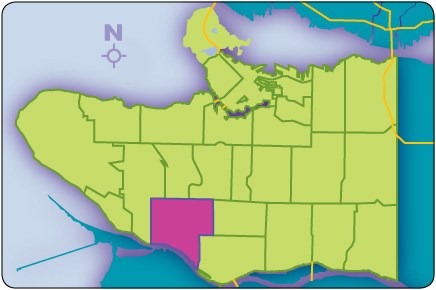
When it comes to defining the boundaries of Kerrisdale, it depends on who you ask. Even the City of Vancouver admits while it has defined boundaries for each of the city's neighbourhoods, they're all up for interpretation.
The official boundaries of Kerrisdale run from West 41st Avenue to Southwest Marine Drive, east to Granville Street/Angus Drive and west to Blenheim. But ask anyone who lives or works in the community and you'll likely hear a different version.
What's commonly considered Kerrisdale actually begins at West 33rd or even West 37th Avenue to the north. Meanwhile, Southlands, which some considered a neighbourhood on its own, is also included within Kerrisdale's boundaries. The heart of Kerrisdale is the shopping district known as "The Village."
The landmark clock at West Boulevard and West 41st Avenue is testament to the community's ties to the early rail line.
It was in 1905, when at the request of B.C. Electric Railway manager R.H. Sterling, Mrs. William McKinnon named the interurban stop at Wilson Road (modern-day West 41st Avenue) "Kerry's Dale," after her family home of Kerrydale, in Gairloch, Scotland. Translated, Kerrydale means "little seat of the fairies." The name was later changed to Kerrisdale. In 1929, when Kerrisdale was part of the Municipality of Point Grey, it amalgamated with the City of Vancouver.
Until recent years, residents of Kerrisdale were primarily of English, Scottish or Irish descent, but today the number of Chinese immigrants moving to the neighbourhood has changed the face of the community. According to the 2011 census, the population of Kerrisdale is 14,732. In 1971, it was 13, 410.
According to a recent economic profile, Kerrisdale residents have larger family sizes and much greater spending power compared to the rest of the city. Residents of employment age tend to be professionals and are more likely to be employed in areas such as finance, business and administration, management, natural and applied science or health professions than on average across the city.


