
OMAHA, Neb. (AP) — Another storm system affected millions of people in the middle of the U.S. on Wednesday, leaving parts of the Midwest and Great Plains under blizzard conditions and a broad swath of neighboring states at risk of high winds and wildfires.
Roughly 72 million people were under a wind advisory or warning, with winds gusting over 45 mph (72 kph), according to Bryan Jackson, a National Weather Service meteorologist.
At this time of year, cold air lingering in the north collides with warm air from the south to produce strong, low pressure systems, Jackson said. But he added that the latest weather was the third storm system to rapidly develop in recent weeks and bring high winds to a large swath of the U.S., a “very active pattern" since February.
At least 42 people died over the weekend when dynamic storms unleashed tornadoes, blinding dust and wildfires, uprooting trees and flattening hundreds of homes and businesses across eight states in the South and Midwest.
Snow for some
A band from southwestern Kansas to central Wisconsin was expected to bring as little as 2 inches (5 centimeters) of snow or as much as a foot (30 centimeters). Combined with high winds, forecasters warned of whiteout conditions.
The Kansas Department of Transportation temporarily closed more than 250 miles (400 kilometers) of Interstate 70 from the Colorado border east to Salina, Kansas. By Wednesday night, nearly all of it had been reopened due to improved road conditions.
The first stretch to close in western Kansas was also impacted by last week's high winds when eight people died after a dust storm resulted in a pileup of 71 cars and trucks.
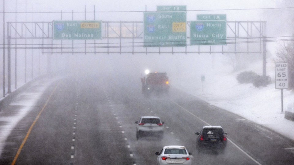
Blizzard conditions early Wednesday led to near-zero visibility in south-central Nebraska, the state patrol said via Facebook, urging people to stay off the roads. There were road closures of more than 160 miles (255 kilometers) of I-80 from Lincoln to Lexington and nearly 70 miles (115 kilometers) of I-29 along the Nebraska-Iowa border. Stalled cars, jackknifed semitrailers, crashes and downed power lines contributed to the chaos.
Around the Iowa-Illinois border, more than an inch of snow was falling per hour, while gusts were as high as 30 mph (48 kph), according to the National Weather Service.
Heavy snow and high winds knocked down tree branches and snapped utility poles. Power was knocked out to more than 140,000 customers in Nebraska, Iowa, Missouri, Arkansas, Tennessee and Indiana, according to PowerOutage.us.
The storm left many with weather whiplash following a springlike Tuesday with temperatures topping 70 degrees Fahrenheit (21 Celsius) in some parts.
High winds and risk of fires
Where it was not snowing, there were still very strong winds. Gusts combined with dry conditions from Texas and Oklahoma through Arkansas and central Missouri raised the wildfire potential.
"Before plants are growing,” Jackson said, “there's a lot of dry fuel out there.”
The fire threat ramped up Tuesday and persisted Wednesday with renewed risk in parts of Oklahoma still reeling from an outbreak of blazes that started Friday. More than 400 homes were severely damaged or destroyed, and at least four people died due to the fires or high winds, officials said.
The Texas A&M Forest Service reported that it responded to 14 new wildfires Tuesday that burned about 29 square miles (75 square kilometers) across Texas.
The agency responded to a fire of about 3 square miles (8 square kilometers) the following day in San Jacinto County, with just a small fraction of it contained.
One fire near Borger, in the state's panhandle, cut power, led to evacuations and threatened more than 1,000 late Tuesday, the city said via Facebook.
“Through quick response and collaborative effort from many departments around our region, the fire remained outside of the City limits, and we did not lose any of those 1201 homes,” the city said.
As of Wednesday night, that fire, originally spanning 350 acres (140 hectares), covered an estimated 500 acres (200 hectares) and was 75% contained, according to the Texas A&M Forest Service.
Crews also responded to dozens of fires in Arkansas, where winds posed additional risk. Four homes in Little Rock were heavily damaged in the southwest part of the city, Fire Chief Delphone Hubbard said during a news briefing, but no fatalities or injuries were reported.
Mayor Frank Scott urged people to heed a burn ban for Pulaski County, saying, “Please do not do anything reckless or careless, because it could create a loss of life."
Part of I-530 southeast of Little Rock was shut down because of smoke from a grass fire, but traffic resumed by the evening.
The midsection of the state saw wind gusts as high as 59 mph (95 kph), according to the National Weather Service.
In New Mexico, where massive walls of dust forced highway closures and resulted in power outages Tuesday, forecasters warned of a return of critical fire weather conditions on Thursday.
Tornadoes possible
Severe thunderstorms were possible in central Illinois with risks of hail, strong wind and tornadoes. Much of Illinois and Indiana were forecast to be under slight risk, with lower risk farther south through the Tennessee Valley.
Severe storms brought strong winds to Indiana, and hail and tornadoes threatened part of the state, the National Weather Service said.
Looking ahead — and eastward
Jackson said the storm would send a cold front across the Eastern Seaboard on Thursday with potential heavy snowfall at higher elevations in New England.
___
Fingerhut reported from Des Moines, Iowa. Associated Press writers John Hanna in Topeka, Kansas, Andrew DeMillo in Little Rock, Arkansas, and Hallie Golden in Seattle contributed.
Hannah Fingerhut And Margery A. Beck, The Associated Press


