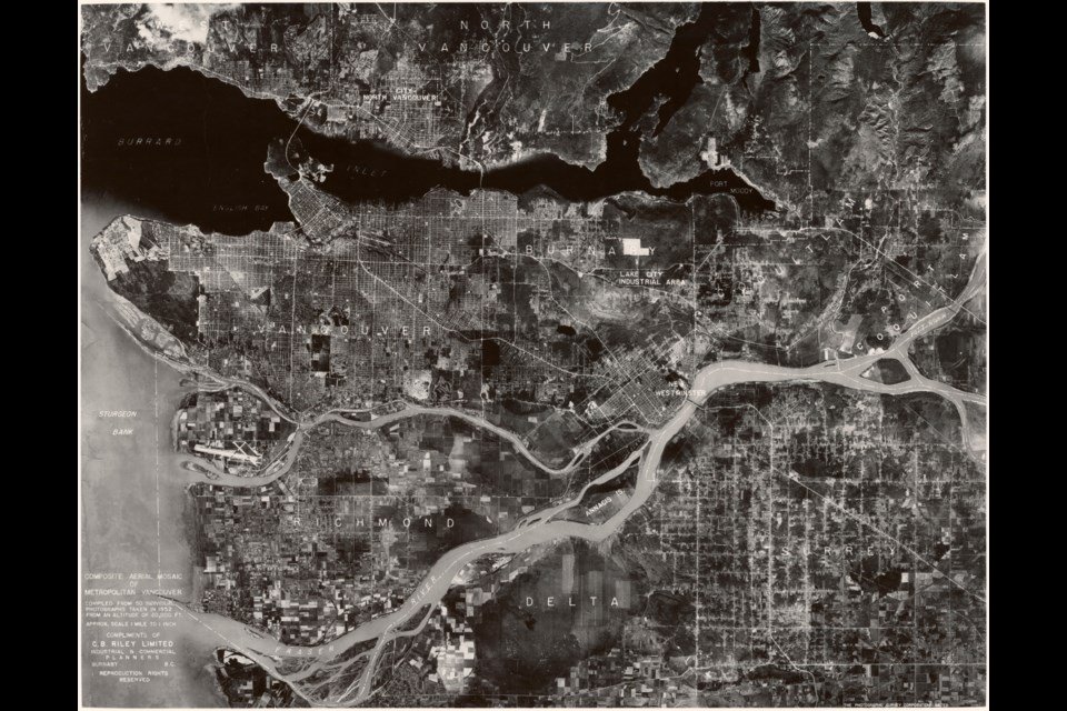
This huge photo compilation took a lot of effort to put together.
The massive image doesn't just capture all of Vancouver, but also all of Richmond, Burnaby, New Westminster...well, pretty much all of Metro Vancouver except the eastern communities and Delta.
It's not just the scale that's impressive, it's the detail. You can zoom in a great deal and check spots that have changed over the years. The eastern edge of False Creek is wildly different, marked with train tracks and industrial buildings, and the highways system is almost nonexistent compared to nowadays.
Lots of infrastructure used daily by thousands of people isn't there, like the Massey Tunnel (if you zoom in you can spot the Ladner ferry docks), the Alex Fraser Bridge (Annacis Island is completely undeveloped) and highways 91 and 17 are still years off. In fact, the barrier the Fraser River creates is rather impressive, with only the Patullo Bridge crossing the main part of the river.
Perhaps the most obvious development is at the airport. In 1952 flying was still an uncommon luxury for most people and the airport is massively underdeveloped compared to the international leading-edge facility on Sea Island now. Instead of hangers for jumbo jets, there are farm fields.
In one area, the opposite has happened. At UBC a huge field can be seen to the northeast of the campus; that's now a forested section of Pacific Spirit Park.
Also notable are the different colours of the water, obvious even in a black and white photo. The muddy Fraser is a pale grey, while the Burrard Inlet is a deep black.
In total 50 photos are stitched together to create the final image, all shot 20,000 feet above Vancouver 70 years ago. The scale is about a mile to an inch when printed, but depending on how much you've zoomed in that'll change.
The company that put it together was an industrial and commercial planning firm based in Burnaby. It's now part of the CIty of Vancouver archives.


