
Tourism has long been an important part of Vancouver's economy as this brochure from 1927 shows.
It's directed to what, at the time, was a growing type of tourist: Motorists. Cars weren't common in Vancouver until the beginning of the 20th century. At first, they were just for the wealthiest residents to get around in the city.
By the 1920s they were increasingly popular. In 1925, there were more than cars in 56,000 in B.C., which had a population of around 600,000 (though the vast majority of cars would have remained in Metro Vancouver and Victoria).
Intercity travel didn't happen right away since the infrastructure had to be built. The first gas station in Canada was created in Vancouver in 1907. Drivers were driving on the other side of the road until 1922.
And highways were a relatively new concept (the first modern highway for automobiles in North America was built in New York state in 1911). Many routes between cities were being paved. Stop lights weren't even used yet in Vancouver, the first traffic signals wouldn't arrive until 1928.
In 1927, this brochure was published to help guide these new tourists arriving in Vancouver. It doesn't just give recent arrivals info about the city but also covers specific things for drivers, like how long driving routes are, parking regulations and how to deal with transit.
In regards to speeding, it's a bit more relaxed than B.C.'s current guidelines.
"All motorists must govern their rate of speed at not greater than is reasonable, having regard to all the circumstances of the occasion," advises the brochure.
What is "reasonable" is not defined. And while cars in the 1920s were much slower on average than current vehicles, the first car to break 200 miles per an hour was built in 1927.
Interesting facts
Perhaps the highlight for someone nearly 100 years later is the list of interesting facts (slide two).
Some are basic, and a couple are still true, like that Greater Vancouver is the third largest city in the "dominion," it has a year-round port and it's the commercial capital of B.C.
It also highlights Stanley Park and Hastings Park with its exhibition areas and "Happyland" (the precursor to Playland).
One fact that some might find humorous is the reputation Vancouver had at the time: "It is famous for its many fine residences and as a 'Own Your Own Home' city," reads one fact.
Some of the other facts are fairly precise, though perhaps wouldn't make it in a travel brochure in 2024. For example Metro Vancouver, at the time, had:
- more than 60 sawmills, shingle mills, and lumber plants
- six grain elevators
- 141.4 miles of street railways
- over 125 churches
Other facts seem more likely to entice tourists, like the 38 theatres, over 50 parks, three horse race tracks, and 15 bowling greens.
One fact, in particular, seems a little boastful to the point of impossible: "Greater Vancouver has unlimited electrical power," proclaims the brochure.
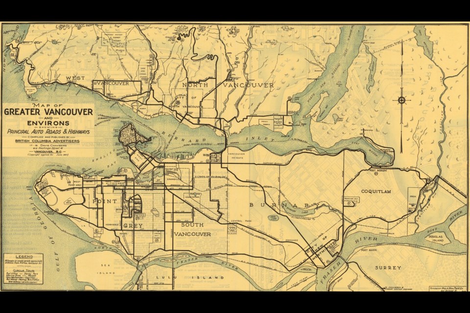
Maps show local city streets
The brochure also has three street maps: one of downtown Vancouver, one of the Metro Vancouver region, and one of New Westminster, the second-biggest city in the area at the time.
The maps show how much has changed in downtown Vancouver, from the filling-in of the east end of False Creek, to the wildly different waterfront on Vancouver's harbour (piers are marked with passenger ship destinations like a train terminal), and with railways crossing much more of the city.
Some places that still are around are marked, like the courthouse (but now it's the art gallery), the Carnegie Library (but now it's the Carnegie Community Centre) and the "new" Orpheum Theatre (which is now a national historic site).


