While fall kicked off last week, the province hasn't cooled off.
On Sunday (Sept. 25), nearly a dozen temperature records were broken in British Columbia and the current forecast calls for more unseasonable weather this week.
It isn't unusual for there to be a couple of sunny stretches in Metro Vancouver in September but this month has been particularly dry.
In a previous interview, Environment Canada meteorologist Bobby Sekhon told Vancouver Is Awesome that the signal for the first month of meteorological fall (September) showed "above-average" temperatures for the Metro Vancouver region.
So far, the province has seen drier-than-average conditions, with plenty of hot weather to boot.
Across B.C. Sunday, 11 temperature records were broken, including ones in Esquimalt, Gonzales Point, Pemberton, Port Alberni, Port Hardy, Puntzi Mountain, Sechelt, Victoria Harbour, the Victoria (Hartland) area, the University of Victoria area, and Whistler.
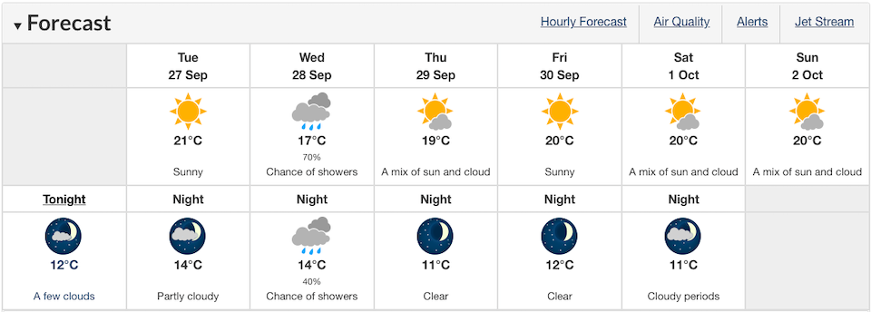
Looking ahead, Vancouverites are expected to see some sweltering humidity Tuesday, with a daily high of 21 C on the coast and an inland high of 25 C that will feel more like 25 C and 28 C, respectively.
Wednesday's forecast includes the only chance for some wet weather this week, with a 70 per cent chance of showers during the day and a 40 per cent chance overnight.
The sunshine is expected to return on Thursday, however, with temperatures climbing to 19 C during the day. Following this, October looks like it will be kicked off with some 20 C highs and double-digit overnight lows over the weekend.
Metro Vancouver weather forecast


