B.C. smashed 13 temperature records this week as a warm weather anomaly continues to dominate most of the province.
On Wednesday, Dec. 27, the City of Vancouver reached a high of 11.9 C around 2 p.m., making it the second-highest temperature for Dec. 27 since 1980 when it reached a high of 12.4 C, according to Vancouver Weather Records.
Environment Canada says high temperature marks were also broken in West Vancouver, where the mercury hit 14 C and shattered a 1986 high by 2.5 C, and White Rock where the high of 13.5 C broke an 88-year-old record.
The Metro Vancouver weather forecast includes more temperatures that are several degrees above seasonal averages. Environment Canada meteorologist Brian Proctor says a combination of El Niño and a ridge of high pressure have kept conditions warm since before Christmas Day.
The ridge has sheltered most of the province from cold weather in a "coastal phenomenon" that pushes the cooler air up to the Yukon.
"We are locked into a windy, warm, and wet pattern until at least New Year's Eve Day," Proctor added, noting that the holiday weekend looks "generally unsettled."
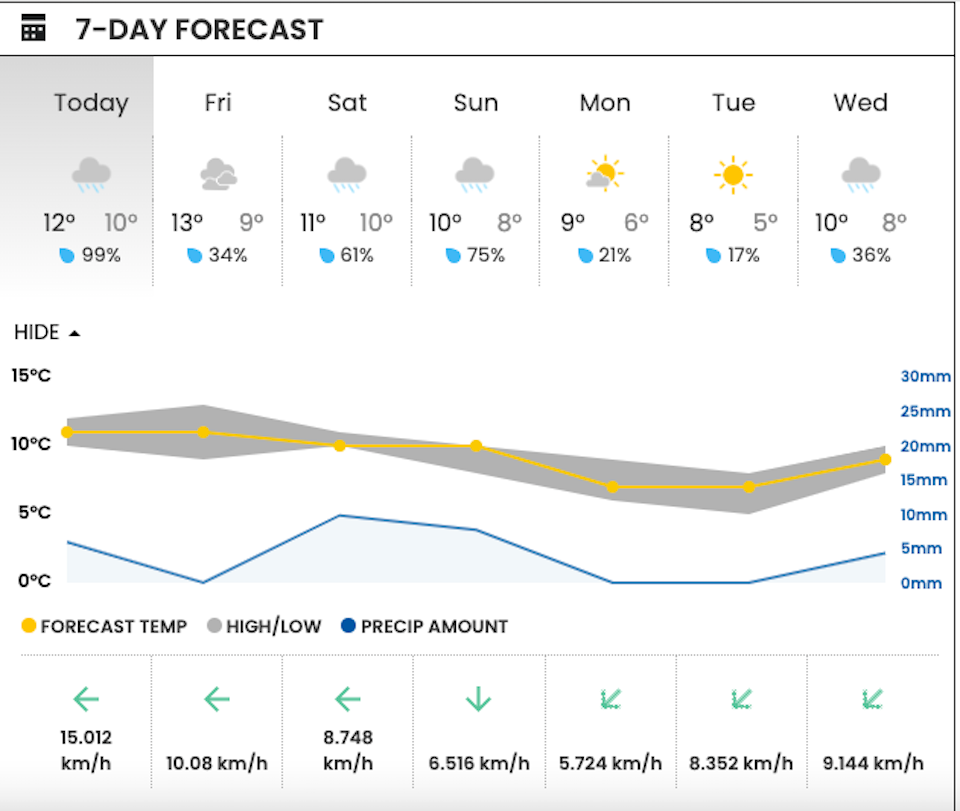
Metro Vancouver weather forecast
While there is expected to be a respite from the stormy weather on Thursday night, another storm is expected to roll into B.C. sometime on Friday.
On Thursday, V.I.A.'s Downtown Vancouver Weatherhood station shows a high of 12 C and an overnight low of 10 C with up to 5 mm of rainfall expected.
The Richmond station is showing slightly cooler temperatures, with a high of 10 C and a low of 9 C, although they are still several degrees above seasonal averages. According to Environment Canada's historical climate data, the seasonal average high for Richmond is 5.7 C with an average low of 0.3 C.
Proctor adds that Thursday will likely be the warmest day in Vancouver over the next week, with temperatures expected to climb to 12 C, which is a couple of degrees below the record set in 1997 (13.9 C).
While the weekend may see some stormy activity, temperatures should continue to sit "above what we would normally see," meaning locals won't face any snowfall during their New Year's Eve celebrations.
The ridge of high pressure is expected to slowly shift westward sometime next week, which will allow temperatures to drop closer to seasonal averages.
The Weather Network notes that this El Niño has also kept conditions significantly warmer across Canada in the weeks leading up to Christmas, adding that it is one of the strongest El Niños on record.

With files from the Canadian Press


